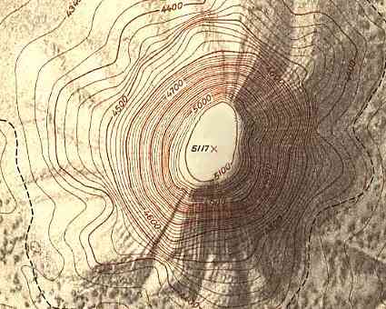
 This topographic map uses a scale of 1 to 4,800. The contour lines are circular in form, denoting a round mass. The close proximity of the lines show that the mountain is very steep and the open lines on the top of the mass shows that it is flat like a plateau. The trend of interest in this map is a large mountain named Devil's Tower.
Friday, April 23, 2010
Topographic Map
This topographic map uses a scale of 1 to 4,800. The contour lines are circular in form, denoting a round mass. The close proximity of the lines show that the mountain is very steep and the open lines on the top of the mass shows that it is flat like a plateau. The trend of interest in this map is a large mountain named Devil's Tower.
Subscribe to:
Post Comments (Atom)
No comments:
Post a Comment